
Florian Wiedmann
Frankfurt University of Applied Sciences
Dr. Florian Wiedmann is a Senior Urban Planner and part-time Lecturer at Frankfurt University of Applied Sciences. He holds a PhD in urban planning and his recent research efforts are focused on the urbanization in the Gulf region. In addition to his academic occupation he is co-founder and principal of ARRUS, an urban planning consultancy located in Frankfurt and Chicago.
Email: wiedmann@fb1.fra-uas.de
Receipt: April 29th, 2015
Accepted: July 05th, 2015
Available online: 01 August 2015
CC BY-NC-ND
Abstract
This paper analyzes the different roots of current residential high-rise clusters emerging in new city districts along the coast of Bahrain’s capital city Manama, and the resulting urban planning and design challenges. Since the local real-estate markets were liberalized in Bahrain in 2003, the population grew rapidly to more than one million inhabitants. Consequently, the housing demand increased rapidly due to extensive immigration. Many residential developments were however constructed for the upper spectrum of the real-estate market, due to speculative tendencies causing a raise in land value. The emerging high-rise clusters are developed along the various waterfronts of Manama on newly reclaimed land. This paper explores the spatial consequences of the recent boom in construction boom and the various challenges for architects and urban planners to enhance urban qualities.
Keywords: high-rise, cluster development, housing, urban planning, Bahrain, Manama
Introduction
Since the end of the 20th century, a new vision in urban development has been introduced in the case of the cities in the gulf, in order to establish emerging service hubs in the region, due to its fortunate geopolitical location between global markets and its remaining oil wealth (Elsheshtawy, 2008 and 2010). The subsequent public investment in infrastructure and the introduction of liberalization strategies caused an unprecedented construction boom at the beginning of the 21st century; subsequently leading to the introduction of various new urban typologies. In general, three distinct phases of urbanization can be distinguished in the case of the entire Gulf region (Salama and Wiedmann, 2013). During the first phase: between the 1940 and 1960, the first oil revenues were used to introduce basic infrastructure, such as electricity and rudimentary road networks. The first multi-story apartment building was built to accommodate the large number of workers (Scholz, 1999). In the second phase, after gaining national independence during 1970, the urban transformation process was dominated by the welfare state mechanisms and a car-based model of town planning (imported by Western architects and planners). Leading to clearly separated mixed-use inner city districts surrounded by a low-rise sprawling urban periphery (Wiedmann, 2012).
The recent liberalization of local real-estate markets in combination with the investment in various mega projects and events, led to rapid urban growth and subsequently the third major urban transformation process; dominated by new construction superlatives (Blum and Neitzke, 2009). As in other emerging cities worldwide, exponential growth has led to various challenges for urban governance to introduce and sustain efficient and diverse urban structures (Adham, 2008). While in already consolidated urban configurations, building typologies are the result of long-term demand-driven incentives within the real-estate markets, Emerging Gulf cities are built in a rather short period of time and by unconventional dynamics (Schmid, 2009; Davidson, 2008). The extensive immigration led to the immediate need for supplementary housing; enforcing both urban sprawl and newly emerging high-rise clusters. In general, two main categories of residential high-rise projects can be distinguished, namely, cluster developments in proximity to urban centers and subsidiary parts of master planned mega projects (Figure 1 and Figure 2).
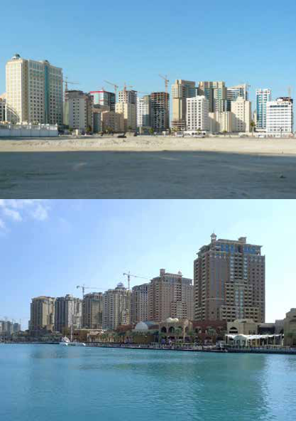
Regarding the first category, the competitive aspect of the private sector, (which has taken over the main direction of the current urban development), is leading progressively to a more and more densely built urban frame around the historic city cores. For instance,in the case of Bahrain’s capital Manama, the view of city skylines from the center towards the coastline consist of increasing building heights; from around three storeys in the center to an average of more than eleven storeys, with a number of landmarks reaching heights of up to 50 storeys along the waterfront (Wiedmann, 2012). In the case of Dubai, the first residential high-rise buildings were built along the fringe of Deira and in recent years a large cluster of high-rise towers has emerged in the Emirate of Sharjah, along the border with Dubai (Blum and Neitzke, 2009). In Qatar’s capital Doha, high-rise clusters were built in West Bay and along the main ring roads. There’s one striking similarity among all these clusters and developments, it can be identified, in the fact that they were all developed on land that was previously designated for low-rise or medium-rise developments (Wiedmann, 2012).
In contrast to these new high-rise cluster developments along the urban fringes and within inner-city districts, the second category of high-rise developments can be found in the case of various mega projects such as: Dubai Marina located in Dubai, Bahrain Financial Harbor in Bahrain, Al Reem Island in Abu Dhabi and the Pearl Island in Qatar. In these cases, high-rise buildings are part of a master planned development plan. The main parallel between all these developments is their high level of exclusivity. In order to attract groups with a high income, the precincts of these developments are often gated or semi-accessible for the public (Wiedmann, 2012, p. 105). Today, it can be stated that essential urban areas of cities in the Gulf region have been transformed into high-rise agglomerations within a period of less than fifteen years.
Applied Methodological Approach
In this paper the residential high-rise developments along Manama’s urban periphery are examined via GIS data; provided by Bahrain’s Survey and Land Registration Bureau in 2008. Due to the impact of the international financial crisis and the subsequent end of rapid urban development in Bahrain the GIS data has remained a reliable source of basic spatial information regarding the current built environment by comparing the data with recently published satellite images. This GIS data is used to calculate the new urban density as well as the general distribution of land use in order to investigate the various outcomes of the major construction boom between 2000 and 2008. In addition to these GIS analyses the existing zoning plans were evaluated in order to examine the coherence between implemented planning efforts and actual urban development.
Last but not least, various field studies were carried out in one case study district in order to investigate the various impacts of residential high-rise clusters on their direct surroundings. In the Kingdom of Bahrain, most high-rise projects have been built in the capital Manama; where the urban periphery is continuously growing due to land reclamation. One main development focus has taken place along the waterfront in the North of Manama, known as Seafront District. The area was previously used as a commercial and administrative center without the integration of any residential developments. In recent years, the first residential high-rise projects were built in key locations within the business district itself and in form of master plan project on reclaimed islands along the coast. The district was therefore chosen as the main case study for this paper.
Historic Urban Development of Manama
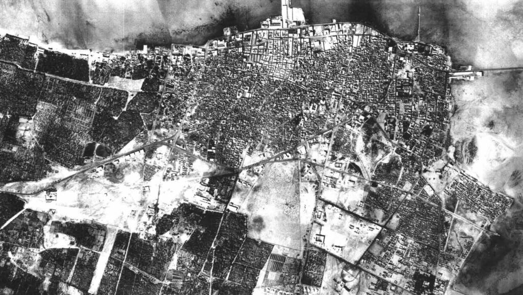
In 1960, the urban area of Manama was concentrated on an area of less than 4 square kilometers along the North-Eastern shoreline of Bahrain’s main island (Figure 3). At this time the outskirts in the South were still occupied by agricultural areas and small rural settlements. Although large areas of land were undeveloped, they were reclaimed along with the coasts in the North and East; where the first causeway was built, linking Manama and Muharraq. After Bahrain gained independence and Manama was made the new capital, more areas were reclaimed along the Northern shoreline in order to expand the country’s first central business district and to develop a modern administrative center. During the 70’s, when the old harbor area was in the process of transforming into a modern CBD, the old harbor Mina Manama lost its function as Bahrain’s main port. A new port was completed in 1962 in the South of Manama (Hamouche, 2008).
Due to Bahrain’s early oil production the modernization of Manama’s city center began during the 40’s. For the most part, the basic layout of roads and the division of land remained true to the original old urban structure because of the ownership by many different individuals of small parcels of land. New urban areas were organized around an orthogonal road system along the periphery of the old center. Along the Northern coast line two- to six-story blocks were developed on reclaimed land and on areas of the former market area, where modern cement buildings replaced the traditional urban fabric during the 50’s. On average the blocks were about 120 meters long and around 20 meters wide and stretched along the old main roads that ran from north to south because of the old canals that lead from the agricultural areas in the south of Manama to the sea. The direction of these roads was also influenced by the direction of the wind, which provided natural ventilation for the densely built market area. The floors above the shops located on street level in the traditional market district were often used as accommodation for foreign the laborers or as offices (Hamouche, 2004).
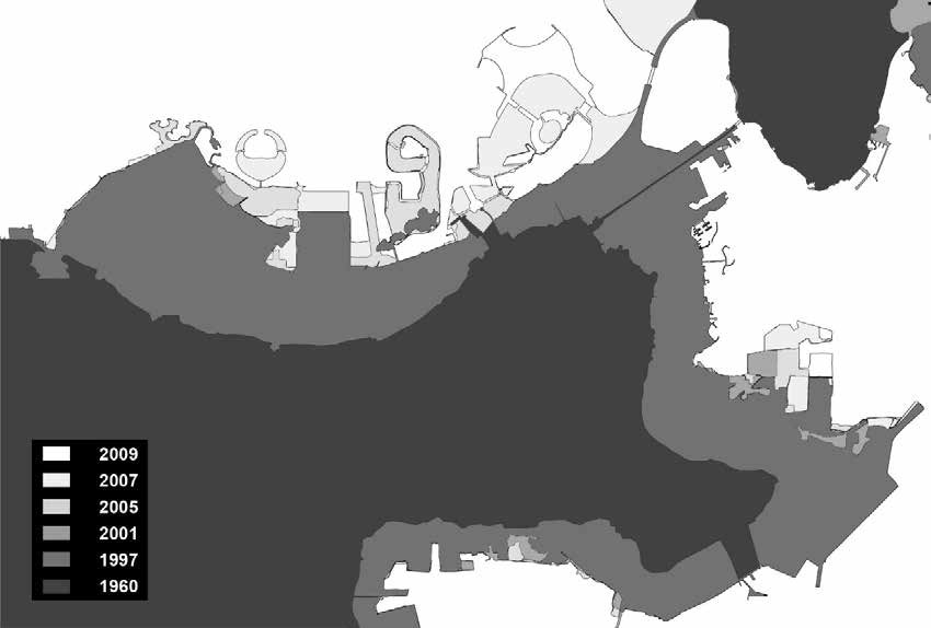
In the North of Manama Government Avenue marks the former coastline, which was shifted more than 300 meters by the reclamation of an area of around 2 square kilometers in the middle of the 20th century (Figure 4). Consequently many: shops, banks and hotels in addition to offices and administrative buildings were developed along both sides of this important access road. While in the west the Central Market at the Pearl Roundabout marked the end of Manama’s Northern business district, the Diplomatic Quarter was developed on its Eastern edge on land that had been reclaimed. The area of the Diplomatic Quarter had already been reclaimed during the 1960s and 1970s but stood mostly empty until more intensive construction of buildings began around in the 1990 (Al Ansari, 2009). Initially, the Diplomatic Quarter was chosen to be developed as a prime location for international embassies and governmental institutions, but due to its highly accessible location the area attracted many businesses to relocate their offices (Wiedmann, 2012).
In 2001, around 205,800 people lived in the governorates of Manama and Jidd Hafs on an area of about 51 square kilometers (Hamouche, 2004). In average, around 50 people lived on one hectare, which is a relatively low average of urban density when compared to the maximum density of over 900 residents per hectare in Manama’s historic city core (Ministry of Housing, 1996). In the outskirts of Manama the urban sprawl that grew during the oil urbanization had a very low urban density, which was mainly due to plots remaining undeveloped because of speculation and the fact that multi-storey blocks were not allowed to be built close to suburban settlements. Consequently, at the end of the 20th century Manama was a typical Gulf city encomprising: a dense old city center, a modern business and administrative district stretching along the highway towards the International Airport, as well as low- to medium-rise suburban outskirts interrupted by vast areas of undeveloped urban areas. The road system of Manama essentially consists of three major highways along the coasts connected to an inner and an outer ring road that runs around the old city core. Due to recent urban growth, a new main business district has evolved. it isknown as the Seafront District, where many new urban development tendencies can be observed, including the emergence of residential high-rise clusters.
Case Study of the Seafront District
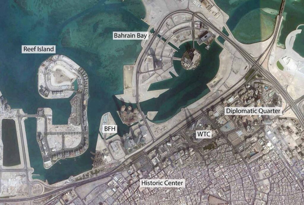
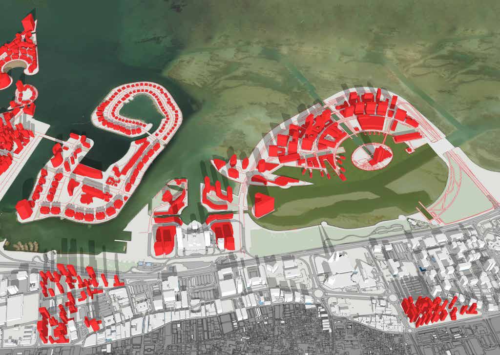
The area of the Seafront District under examination, is the portion stretching more than 3.2 kilometers along the Northern coast; covering a reclaimed area of around 1.8 square kilometers. Its current expansion areas in the North are three master planned developments, namely, Bahrain Financial Harbour, Bahrain Bay and Reef Island, which together add an extra of 1.4 square kilometers of reclaimed land to the Seafront District (Figure 5). While the Western part of the Seafront District is occupied by the Central Market, the Eastern part is occupied by the Diplomatic Quarter covering an area of around 41 hectare. In the center of the Seafront District many administrative and commercial buildings have been developed in addition to several hotels. In addition to its function as Bahrain’s administrative and business center, the Seafront District has recently become attractive as a residential area. This new trend is mainly due to the high accessibility of the district through the causeway to Saudi Arabia and the new laws permitting foreigners to own properties in Bahrain.
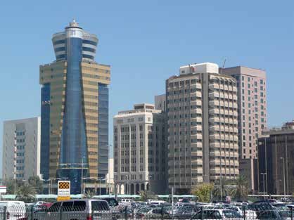
The main access road of the district is the King Faisal Highway along the coast, which links Manama to the International Airport in Muharraq and the causeway to Saudi Arabia. In the center of the Seafront District 1.7 hectare have been made free for the development of Investment Buildings Type B-A offering a possible floor area ratio of 12.0, with no restrictions on building height. In accordance with this new zoning, a first residential tower with 21 floors has been completed in 2008. Further East another 23-floor residential tower has been completed. In order to provide sufficient parking for each of the 70 apartments a five-story car park has been built at the base of the building.
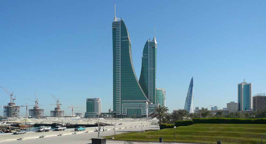
In the East, the Sheraton Hotel stands next to the Bahrain Commercial Complex, also known as the Sheraton Complex, which includes a shopping center and the 18-storey Sheraton Tower. Recently, the shopping center was expanded by the Bahrain World Trade Centre development. After a construction period of four years, the 50-storey towers were completed in 2008, becoming one of Bahrain’s most remarkable modern landmarks due to their unusual design and their height of 240 meters, which makes them the second tallest buildings in Bahrain. The entire Diplomatic Quarter comprises a total of 52 high-rise buildings. Approximately 22% of the total plot area of the Quarter consists of hotel complexes while around the 49% consists of plots reserved for: commercial, residential or administrative developments. The size of the overall area available for development in the Seafront District is around 60 hectare, of which 58% will be developed with high-rise projects. The completion of two residential towers marked the beginning of a new trend of constructing residential high-rises in Manama’s central business district. in addition to commercial buildings such as banks most future projects can be expected to be residential high-rises due to the growing freehold property market in Bahrain. In addition to the developments along the coast, three master plan projects were launched on newly reclaimed land in form of islands in the beginning of the 21st century.
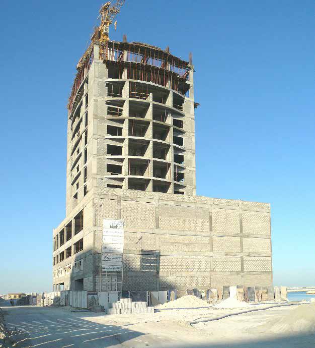
In order to establish the district as Bahrain’s future financial hub, the Bahrain Financial Harbour has been initiated (Figure 6). While the Financial Centre, which is the first development phase of the Bahrain Financial Harbour (BFH) project, has already been completed, the next two development phases have been delayed due to the international financial crisis in 2008. The whole development area is divided into 10 different projects, which are further subdivided into a total of 28 plots. The BFH includes the Villamar project, which is still under construction. With more than 50 floors, the three residential towers rise up to 220 meters and their bases are linked by a winding four-story building, which will contain shops and restaurants. On a separate island of around 8,900 square meters in the west of the Residential South Island, the 45-storey Diamond Tower will also include residences. In addition, the Northern Island has been designed to be a second residential development site, where the construction of six residential towers will be launched. All the residential projects will comprise around 10 towers with up to 50 storeys. It is currently expected that about 7,000 people will reside in the Bahrain Financial Harbour and around 8,000 workers are expected to come and go daily after its completion (BFH, 2009).
While the Bahrain Financial Harbour includes around 14 high-rise buildings with up to 53 storeys, there will be about 20 towers with 34 to 59 storeys in Bahrain Bay as well as three residential high-rises on Reef Island. All three developments will add 26 residential towers to the Seafront District. All in all, the Seafront District currently contains a total of about 40 high-rise buildings with more than 10 storeys. In the future it is expected that in addition to the 37 high-rise buildings within the three projects, several high-rise projects will follow in the unbuilt areas within the older district area along the coast. Transforming the former business district into a mixed-use waterfront with high built densities (Figure 7).
Key Planning Challenges of High-Rise Clusters in Manama
The majority of residential high rises along the coasts of Manama were developed with an average building height of more than twenty storeys between 1998 and 2008. This transformation from medium-rise urban fringes to a rapid verticalization process along Manama’s waterfront is one of the main characteristics of the current urbanism in Bahrain; which has been enforced by a laissez-faire planning approach: introducing new zoning plans for these reclaimed and areas permitting investment buildings with a floor area ratio (FAR) of up to 12.5 in most locations. In addition many master plan developments were added, in which cases the planning authorities had less influence on the actual built density rather than the infrastructural investment of the master developer.
Today, a growing lack of infrastructure and public areas are endangering the consolidation process of these high-rise clusters. While the private sector is focused on individual projects, the parallel development of general public spaces, recreation areas and pedestrian zones has been completely neglected by both private and public sector. Another reason for the decreasing quality of the built environment is the short distances of sometimes less than five meters between multi-story buildings causing shaded and badly ventilated areas. This is due to the fact that the initial physical planning of the districts was usually done for medium-rise buildings. Furthermore, The change in the former zoning plans permitting residential developments in previous commercial areas has furthermore led to an insufficiency in infrastructural capacity, particularly regarding parking and social services.
Due to the increasing deficit of parking spaces within districts, recent high-rise projects have begun to integrate multi-storey car parks with up to six floors. This is leading to an even more pedestrian-unfriendly urban environment and reduced potentials to integrate services in ground floors (Figure 8). Thus, despite the development trend of including certain services in new projects, such as the Nomas Towers in Juffair, large parts of the new districts do not integrate commercial or social facilities. In addition to missing land-use integration, the lack of public transport is leading to increasing congestion. The rapid growth has also had an impact on the electricity supply, the capacity of which has been exceeded in certain areas. This shortage of supply is due to an evident lack of impact studies and planning in addition to an absence of restrictions and their implementation. For instance, the responsibility of landowners to participate in the development of sufficient infrastructure by paying levies to public suppliers.
Furthermore, a lack of urban design has led to a built environment consisting of isolated high-rise projects with almost no response to adjacent buildings. While in the past the color of buildings was restricted, recent developments do not have to follow any design guidelines. Consequently, the small number of restrictions on architectural design has led to the widespread development of concrete buildings of various forms with large glass facades (Figure 9). This architecture proves to be inappropriate for this climate has not only led to an unecological built because, it environment but also to a rather incoherent urban landscape with hardly any distinct identity. The missing integration of public realm connecting the various developments and public transportation are however the most severe deficits in the case of the new high-rise clusters and island projects challenging current physical planning. The various island developments have led to a fragmented and isolated urban fabric with extensive privatization of coastal areas. Henceforth, forcing the various potentials of residential high-rise developments to enhance urban sustainability, which are currently undermined by certain development patterns.
Outlook: The Potentials of Residential High-Rise Clusters
Based on the basic model of sustainable urbanism, which includes ecological balance, economic stability and social equity, three main urban qualities can be distinguished: urban efficiency, diversity and livability. While an efficient urban structure is needed to reduce travel distances and thus reduce energy waste, urban diversity is a key for economic growth in all areas, including the integration of low-income communities (Wiedmann and Salama, 2012). Social equity is relying on the supply of livable urban environments for all social groups leading to the stimulation of individual care-taking initiatives regarding surrounding urban, communal and public spaces, which is closing the circle toward more ecological urban development (Chapple, 2014).
The supply of an efficient urban structure, is to a large extent the result of the implementation of guidelines and regulations related to policies and physical planning in combination with public investment in certain development strategies such as public transportation. In general, it can be stated that an efficient urban structure relies on a balanced distribution of urban densities: a high level of land use integration and an efficient infrastructural network (Newman and Kenworthy, 1999). In the case of infrastructure,m as well as general building standards, energy efficiency and recycling processes, the investment and promotion of new technologies are important factors in enhancing the ecological balance of cities. Furthermore, the introduction of rating systems, such as the American LEED (Leadership in Energy and Environmental Design), can play an important role in stimulating investment from the private sector in more energy-efficient buildings.
In the case of high-rise developments, there are two contrary positions regarding their contribution to urban efficiency. On one hand, they are by themselves highly energy-consuming buildings without the application of comparatively cost-intensive measures such as the integration of state-of-the-art technologies. On the other hand, planners and architects emphasize their important role in developing highly integrated and dense urban districts that can be easily served by public transportation. Moreover, the integration of housing in central business districts, such as the Seafront District in Manama, can lead to a significant reduction in the commuting distances between homes and work places.
While urban governance is responsible for the supply of plans, regulations and infrastructure; demand-driven dynamics are the key for the development of the urban diversity needed for a stable economic climate. Particularly the dynamics between investors as property suppliers and the actual end-users of developments define the actual diversification of urban spaces. Thus, physical planning needs to create and sustain synergies between investment opportunities and the wide range of businesses and social groups by promoting urban density and a high level of accessibility. Subsequently, all forms of businesses need to benefit from the overall market place. This can be best explained by comparing low-rise suburban typologies, served by shopping malls and dependent on individual traffic, with dense downtown districts containing a variety of business streets such as high streets, attractive pedestrianized zones and small district markets. Another key aspect in promoting urban diversity is the prevention of social segregation. The integration of housing for various social classes is an important factor for enabling all income groups to gain access to potential buyers of their products and services (Chapple, 2014).
Residential high-rises can therefore play an important role by providing attractiveness for groups with high income in the inner city districts and at the same time offering a high level of safety. The reduction of the usual exodus of high income groups to sprawling outskirts is one of the particular challenges in emerging countries in order to prevent an increasing dependency of purely low income groups on public subsidies in the inner cities. Diversified, well connected, well serviced and attractive inner-city high-density housing can at the same time counter the danger of an oversupply of exclusive housing as an investment asset and a consequently increasing vacancy rate as well as the movement away of all the groups with a lower income due to the increased living costs in these areas.
The third quality expressing sustainable urbanism is livability. Like efficiency and diversity, livability is a multifaceted dimension based on various factors. As a whole, the degree of a city`s livability is based on the long-term satisfaction of all social groups. The reasons for an attractive urban environment include various aspects such as affordability, housing standards, the quality of services as well as mobility and cultural concerns. Urban spaces thus need to create a highly familiar atmosphere in line with cultural values, expressed in certain aesthetics as well as in the role of the public realm. All these factors together create a livable environment, which is the basis for social equity when it is created for all social groups. High-rise buildings can, on one hand play an important role in enhancing urban livability by offering a new modern lifestyle or by enabling accommodation close to job opportunities; or by creating new urban images in the form of modern contemporary skylines.
Conclusion
On the basis of the three main urban qualities described as the foundation for sustainable urbanism, high-rise typologies undoubtedly have their distinct potential to strengthen urban qualities but the application of these typologies needs to be carefully planned and regulated. In the context of fast growing cities, such as Manama, residential high-rise buildings offer an opportunity to establish highly integrated urban districts with a decreasing dependency on cars as prime mode of traffic. At the same time, the increasing urban density is a massive challenge for all local planning authorities with regard to the integration of sufficient infrastructure and an appropriate balance of high-rises and open spaces in order to avoid highly congested urban districts and rapidly shrinking attractiveness and quality of urban life. A further challenge is the high energy consumption of high-rise buildings due to low construction standards.
In spite of these major challenges, it is expected that the construction of residential high-rise buildings will increase in Bahrain, which is particularly due to: the on-going demand on new housing, the need of employees to reside in accessible locations due to frequent traffic congestion and the high land prices in central locations. Moreover, newly emerging global lifestyle preferences play an important role in the current verticalization of housing in the main urban centers in Bahrain. It should be noted that high-rise typologies are a rational consequence of rapid urban growth processes rooted in current real-estate market dynamics, which are often criticized for being not sustainable. However today, architects and planners are, facing the day-to-day challenge of dealing with this new and complex building typology in the best way they can, in order to unlock all of its potential for more sustainable development and to oppose all hazardous effects. In the case of Bahrain urban fragmentation has to be approached by introducing public transportation networks and strict design guidelines. In addition, new regulations have to be implemented in order to involve the private sector within the development of spaces destined for leisure and needed social infrastructure.
References
Adham, K. (2008). Rediscovering the Island: Doha’s Urbanity from Pearls to Spectacle, in Elsheshtawy, Y. (ed.), The Evolving Arab City, London: Routledge.
Al Ansari, F. (2009). Public Open Space on the Transforming Urban Waterfronts of Bahrain – The Case of Manama City, PhD thesis, Newcastle: Newcastle University.
BFH – Bahrain Financial Harbour (2009). Retrieved February 6, 2009, from http://www.bfharbour.com/html/faq/faq_development.htm.
Blum, E. and Neitzke, P. (2009). Dubai: Ein Zwischenbericht ueber die groesste Baustelle der Welt. Basel: Birkhäuser.
Chapple, K. (2014). Planning Sustainable Cities and Regions: Towards More Equitable Development. Oxon: Routledge.
Davidson, C. M. (2008). Dubai – The vulnerability of success, New York: Columbia University Press.
Elsheshtawy, Y. (2008). Cities of Sand and Fog: Abu Dhabi’s Global Ambitions, in Elsheshtawy, Y. (ed.), The Evolving Arab City, London: Routledge.
Elsheshtawy, Y. (2010). Dubai: Behind an Urban Spectacle. London: Routeledge.
Hamouche, M. B. (2004). The Changing Morphology of Gulf Cities in the Age of Globalisation. The Case of Bahrain, in Habitat International, 28, 521-540.
Hamouche, M. B. (2008). Manama: The Metamorphosis of an Arab Gulf City, in Elsheshtawy, Y. (ed.), The Evolving Arab City, London: Routledge.
Ministry of Housing (1996). General Report on Housing and Urban Development in Bahrain, in Habitat II, The United Nations Conference on Human Settlements, Istanbul: UN Habitat.
Nabi, M. N. (2000). Rapid Urban Expansion and Physical Planning in Bahrain, Manama: Ministry of Housing Press.
Newman, P. and Kenworthy. J. (1999). Sustainability and Cities: Overcoming Automobile Dependence. Washington DC: Island Press.
OBG – Oxford Business Group (2009). The Report: Bahrain 2009, London: OBG Press.
Schmid, H. (2009). Dubai: Der schnelle Aufstieg zur Wirtschaftsmetropole, in Blum, E. and Neitzke, P. (eds.), Dubai – Stadt aus dem Nichts, Berlin: Birkhaeuser.
Salama, A. M. and Wiedmann, F. (2013). Demystifying Doha: On Architecture and Urbanism in an Emerging City. Farnham: Ashgate.
Scholz, F. (1999). Die kleinen Golfstaaten. Gotha: Justus Perthes Verlag GmbH.
Wiedmann, F. (2008). Sustainability: The Challenge of Urban Development Strategies in the Gulf. In: Mustafa A., Al Qawasmi J. and
Mitchell K. (eds.) Instant Cities: Emergent Trends in Architecture and Urbanism in the Arab World. Amman: CSAAR Press.
Wiedmann, F. (2012). Post-oil Urbanism in the Gulf: New Evolutions in Governance and the Impact on Urban Morphologies. Stuttgart: SVH Verlag.
Wiedmann, F., Salama, A. M. and Thierstein, A. (2012). Urban Evolution of the City of Doha: An Investigation Into the Impact of
Economic Transformations on Urban Structures, in JFA/METU: Journal of the Faculty of Architecture, 29(2), 35–61.